North Carolina’s Water Supply Watershed Protection have been in effect since 1992. The law provides for the protection of North Carolina’s watersheds which are natural areas of drainage, including all tributaries contributing to the supply of at least one major waterway within the State, the specific limits of each separate watershed to be designated by the Commission. Based on the level of the development of these areas, the watershed have been given designations of Water Supply I to Water Supply V (with I being undistributed lands and V being primarily developed).
There are three watersheds within the Town of Mooresville; the Lake Norman WS-IV (both critical and protected areas); the Back Creek WS-II (protected area); and the Coddle Creek WS-II (protected area).
To protect the water supply located within the watersheds, landowners and developers are restricted from developing real estate with impervious structures and ground coverings beyond a certain percentage (or density) of the property. This density varies by watershed classification, the level of density sought to be used, and the level of stormwater control methods implemented at the site (amongst other items and concerns).
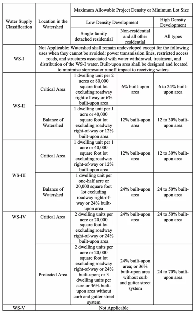
In Mooresville, landowners and developers wishing to develop high-density projects are generally restricted to 30% maximum built-upon area (“BUA”) in the protected areas of both the Back Creek and Coddle Creek watersheds, 50% maximum BUA in the critical area of the Lake Norman Watershed, and 70% maximum BUA in the protected area of the Lake Norman watershed.
However, North Carolina has recognized the need for some leniency in these standards to allow for land to be developed in productive and economical fashion. The two main methods by which this is allowed are by 1) density averaging and 2) the 10/70 option.
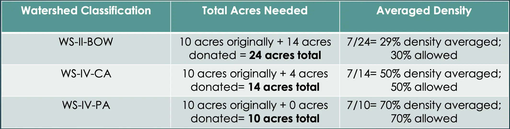
Density Averaging Option
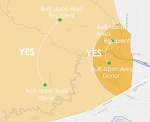
Density averaging allows for landowners and developers to average development density across the property being developed and up to two additional noncontiguous parcels. The ability to utilize density averaging across multiple parcels is a statutory right allowed by the General Assembly since 2012 and cannot be infringed upon by a local government’s waters supply watershed program.
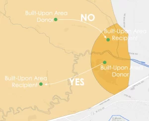
This right does come with some restrictions, the most important of which is that all properties being utilized for density averaging purposes must be within the same watershed. There are additional considerations to remember here when it comes to the critical and protected subcategories contained within a watershed. Protected areas can donate density to protected areas; critical areas can donate density to critical areas, and critical areas can donate density to protected areas. However, protected areas can never donate density to critical areas ever.
To give an example of how density averaging is supposed to work under the guidelines set forth by the General Assembly, let’s assume Developer X has purchased a 10-acre property located in a prime business area and wants to build out 7 acres with a building, parking lot and other impervious areas for a total of 70% density. However, the property is in a Watershed-II protected area that only allows for 30% density under the high-density project standards. To reach a 30% density for a build-out of 7 acres, Developer X will need an additional 13 1/3 acres to reach the desired density (23 1/3 acres X 30% maximum BUA = 7 acres). To obtain these additional necessary acres, Developer X can go obtain these additional acres across up to two noncontiguous properties and place them under a conservation easement that is to be placed on the deed and kept in an undeveloped state.
Unfortunately, despite density averaging being a statutory right, the Town of Mooresville has denied landowners and developers to utilize this option. The Town has told developers who wished to use this option in the past that it is not allowed and they have declined to process applications under the state law as they are required to do so under law. After more than 8 years of being allowed under the statute, the Town has finally stated that they plan to adopt a density averaging ordinance via a text amendment; however, this text amendment appears to be overly restrictive and will essentially prevent landowners and developers from being able to utilize density averaging in Mooresville.
10/70 Option
The 10/70 option is a method allowed under the North Carolina Administrative Code that allows for a maximum of 10% of the land area of a water supply watershed outside of the critical area and within a local government’s planning jurisdiction may be developed with new development projects and expansions of an existing development of up to 70% BUA. This is not a density averaging allowance and it cannot be used in conjunction with the 10/70 option to allow for greater than 70% density. This option may be adopted by local governments in their water supply watershed programs, but it is not required that they do so
The amount of land area available under this option was the amount of watershed land contained within the local government’s jurisdiction as of July 1, 1993. The allocated amount in 1993 holds true today; subsequent incorporations, annexations, land acquisitions, etc. do not change this number. Only approved joint resolutions between local governments that transfer available 10/70 land that is approved by the Environmental Commission will change the allocation.
To illustrate how the 10/70 option operates, assume that Town Z had a total non-critical watershed area of 5,000 acres as allocated in 1993. However, since that time, Town Z has grown massively and now has 25,000 acres in a non-critical watershed area. Unless Town Z has entered a joint resolution to obtain greater 10/70 option allocations, Town Z may only consider the original 5,000 acres as available for 10/70 option calculations and as such has only 500 acres within its jurisdiction that can be developed up to 70% density.
Furthermore, the available 10/70 acreage is not just the built-upon area; it is the who area of the parcel. So, if a developer applies and receives a permit to use the 10/70 option on a 20-acre property, they may develop up to 14 acres, but the full 20 acres is subtracted from the original 500 acres available under the option.
Mooresville has adopted a 10/70 option within the Town’s ordinances that is more restrictive than the option as set forth under the Administrative Code. Although local governments can adopt a more restrictive 10/70 option, they must provide public notice, allow for public comment, and submit the ordinance to the DEQ for approval. Here, it does not appear that Mooresville has done any of these. Nor does it appear that they are properly calculating the land they have available under the 10/70 option as they cannot provide an acreage amount available under the option and appear to be added more land to the area available for 10/70 as the town expands. The Town needs to rewrite its 10/70 option ordinance to allow for public notice and comment and calculate the area they have available to utilize under the 10/70 option.